
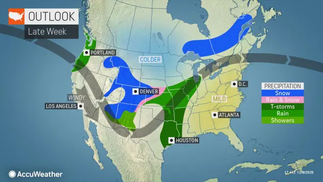
Meteorologists are growing more confident on the exact track and strength of a late-week snowstorm expected to unleash wintry precipitation across an approximately 2,000-mile-long corridor from the southern Rockies in the United States to southern Canada.
The storm won’t reach blockbuster status, but a storm of intermediate strength will not only impact a large swath of the U.S., it will also straddle the major metro areas of Chicago and Milwaukee, according to AccuWeather meteorologists, who have been tracking the storm potential for several days. The storm will begin to put down snow in portions of New Mexico and Colorado by Friday, and it won’t conclude until Sunday over portions of southern Ontario and western Quebec.
CLICK HERE FOR THE FREE ACCUWEATHER APP
The first flakes of snow from the storm are likely to fall Thursday and early Friday over the mountains of northern New Mexico and Colorado.
Detroit is not likely to receive snow from the main part of the storm, but the heaviest snowfall of 6-12 inches is expected across areas farther to the north across the northern part of the Lower Peninsula of Michigan. Even without this storm, Detroit is well ahead of seasonal snowfall, when compared to Chicago, with 6 inches thus far.
A few locations in the northern part of the Lower Peninsula of Michigan may also approach the AccuWeather Local StormMax™ of 18 inches.
Across the border in Canada, places like Sudbury, Ontario, could also be buried under 6-12 inches (15-30 centimeters) of snow, with an AccuWeather Local StormMax™ of 18 inches (45 centimeters), according to Anderson.
As AccuWeather forecasters have been warning since earlier this week, colder air is forecast to wrap in on the back side of the storm before dry air takes over. Intermittent snow and snow showers could develop across areas that will get only rain during most of the storm over parts of the Ohio Valley, central Appalachians and eastern Great Lakes area.
Bands of lake-effect snow can become intertwined with the last part of the storm from northern Indiana and western Michigan, eastward through Ohio, western Pennsylvania and western and central New York state from Sunday to Monday. Roads may be wet during the first part of the weekend, but forecasters explained that motorists should be prepared for wintry conditions on the backside of the storm later in the weekend.

“Even though the Upper Peninsula of Michigan and northern Wisconsin now appear likely avoid the bulk of the storm, there is still the potential for a light to moderate snowfall from lake effect in the storm’s wake in these areas,” AccuWeather Meteorologist Matt Benz said.
Unless there is a drastic northwestward shift in the storm, Minneapolis should avoid a big snowfall and may avoid snow altogether this time. People in cities such as Omaha, Nebraska; Des Moines, Iowa; Peoria, Illinois; Lansing, Michigan; Madison, Wisconsin; and even Kansas City, Missouri; should closely monitor the forecast as subtle shifts in the storm track could mean the difference between snow showers and enough snow to shovel and plow.
On the storm’s warm side, over the Southern and Eastern states, rain is in the offing for at least part of the weekend. That may not be the most problematic weather factor for motorists and airline passengers. Patchy fog may develop and lower visibility as warm and moist air flows over the chilled ground in Detroit, Pittsburgh, New York City, Boston, Philadelphia, Atlanta and Charlotte, North Carolina.


