Severe storms heading for West Coast, then speeding east originally appeared on abcnews.go.com
Several storms this week are forecast to hit the West Coast and then move across the country.
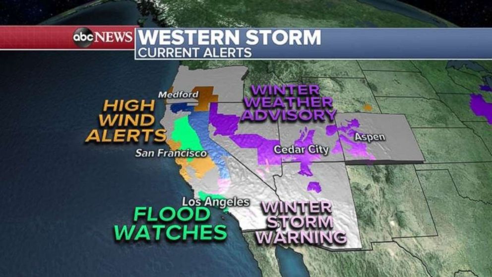
Seven states from California to Colorado are under snow, flood or high-wind alerts this morning as areas burned by wildfires in Santa Barbara County are being evacuated today because of potential weather-related threats including mudslides.

Today, the first system hitting the West is bringing heavy rain and potentially more mudslides and flash floods. Heavy snow is likely in the mountains, with strong winds along the coast.
This first system should then move through the Midwest tomorrow and into the Northeast on Thursday night, into Friday.
The heaviest snow will be inland, with rain expected from Washington, D.C., to New York City. Boston probably will see some snow.

The next West Coast storm is expected on Thursday, and it, too, will track across the U.S. very quickly, reaching the Midwest by Friday night, into Saturday. It should reach the Northeast Saturday, into Sunday.
Chicago, Cleveland and Detroit, and parts of the inland Northeast, should watch out for heavy snowfalls. This storm also should deliver rain from D.C. up to Boston.
Over the next few days, some parts of the West, from Oregon down to California, may see half a foot of rain.
The Sierra Nevada may see 5 feet of snow.


