An East Coast storm will develop early next week, and it may bring some locations in the Midwest, Appalachians and Northeast their first accumulating snow of the season.
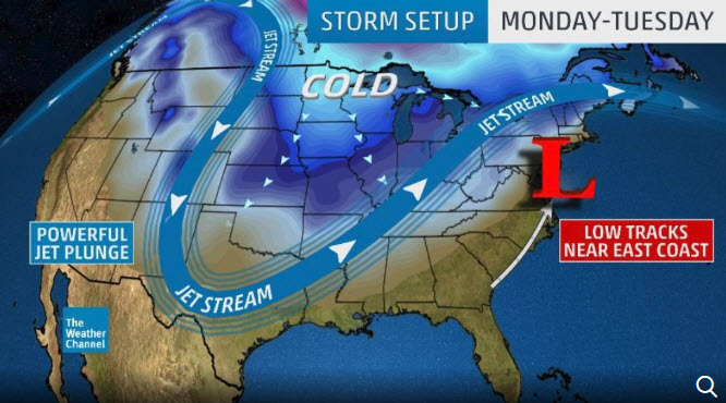
In order to get that potential snow, we’ll need cold-enough air. That will most certainly be the case in the nation’s mid-section, as surges of arctic air bring the coldest air of the season. Monday, the jet stream will take another pronounced southward plunge over the central U.S.
When this southward jet stream plunge pivots eastward, low pressure typically forms at the surface and strengthens near or off the East Coast. This system will produce snow if moisture from the storm interacts with cold-enough air, but where the cold air doesn’t hold, rain will dominate instead. Moderate to locally heavy rainfall is expected across the South and into the East. Typical for any potential storm this far out in time, there are key uncertainties that will determine who sees snow, who sees rain, how much of each fall and how windy this storm will be. The Story Continues on The Weather Channel
When this southward jet stream plunge pivots eastward, low pressure typically forms at the surface and strengthens near or off the East Coast. This system will produce snow if moisture from the storm interacts with cold-enough air, but where the cold air doesn’t hold, rain will dominate instead. Moderate to locally heavy rainfall is expected across the South and into the East. Typical for any potential storm this far out in time, there are key uncertainties that will determine who sees snow, who sees rain, how much of each fall and how windy this storm will be. The Story Continues on The Weather Channel

